
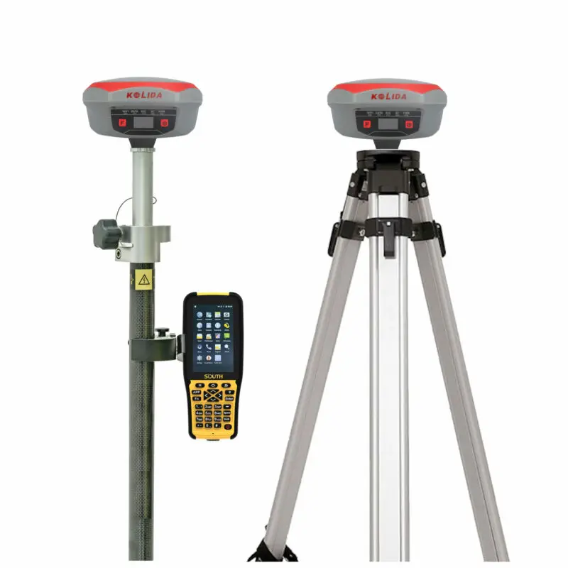
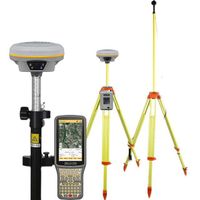
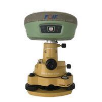
Advanced Hi-target V90 Survey Instruments Differential GPS Rover Kolida K1 Pro GNSS RTK for Construction
- $9150.00 / 2 - 9 sets
$8900.00 / >=10 sets - 2 sets
- Shanghai Newdi Navigation Technology Co., Ltd.
- Shanghai, China
- Mr Allen Niu
| Package Preview: | ; | Warranty: | 1 year; |
| GLONASS: | L1C/A, L1P, L2C/A, L2P, L3; | Initialization: | time <10s; |
| Tilt Angle: | up to 60 degrees; | Single gross weight: | 8.000 KG; |
| Place of Origin: | Zhejiang, China; | Static and Fast Static: | Horizontal: ±2.5mm+0.5ppm Vertical: ±5mm+0.5ppm; |
| Code differential GNSS positioning: | Horizontal: ±0.25m+1ppm Vertical: ±0.50m+1ppm; | Real-time kinematic (RTK): | Horizontal: ±8mm+1ppm Vertical: ±15mm+1ppm; |
| BeiDou: | B1, B2, B3; | Packaging Detail: | Advanced Hi-target V90 Survey Instruments Differential GPS Rover Kolida K1 Pro GNSS RTK for Construction In hard engineer carrying case,then into carton; |
| Certification: | Reach; | Brand Name: | Kolida; |
| Model Number: | K1 Pro; | Channels: | 336 GNSS channels (672 channels optional); |
| Selling Units: | Single item; | GPS: | L1C/A, L1C, L2C, L2E, L5; |
| Product Name: | Kolida k1 pro; | Customized support: | OEM; |
| Single package size: | 45X54X38 cm; |
Advanced Hi-target V90 Survey Instruments Differential GPS Rover Kolida K1 Pro GNSS RTK for Construction

Specification:
|
GNSS characteristics
|
|
336 GNSS channels (672 channels optional)
|
|
GPS: L1C/A, L1C, L2C, L2E, L5
|
| GLONASS: L1C/A, L1P, L2C/A, L2P, L3 |
|
BeiDou: B1, B2, B3
|
| Galileo: E1, E5A, E5B, E5AltBOC, E6 |
| IRNSS: L5 - SBAS: L1C/A, L5
(QZSS, WASS, MSAS, GAGAN, EGNOS) |
| Global Correction Service(MSS L-Band) |
| Initialization: |
| time <10s, reliability >99.99% |
| Supported data formats: |
|
RTCM 2.1, RTCM 2.3, RTCM 3.0, RTCM 3.1,
RTCM 3.2, CMR CMR+
|
|
Output data formats:
|
|
NMEA 0183, PJK plane coordinates, Binary code, Trimble GSOF
|
|
L-band Correction Service |
| Star-fill: 5 minutes, down to 2 cm accuracy |
| Star-Link: down to 2 cm accuracy (need subscription) |
| Inertial Measurement |
| Tilt Angle: up to 60 degrees |
| Accuracy: down to 2cm |
| Positioning Accuracy |
| Code differential GNSS positioning |
| Horizontal: ±0.25m+1ppm |
| Vertical: ±0.50m+1ppm |
| SBAS: 0.5m (H) 0.85m (V) |
| Static and Fast Static |
| Horizontal: ±2.5mm+0.5ppm |
| Vertical: ±5mm+0.5ppm |
| Real-time kinematic (RTK) |
|
Horizontal: ±8mm+1ppm
|
|
Vertical: ±15mm+1ppm
|
|
Network RTK (VRS, FKP, MAC)
|
|
Horizontal: ±8mm+0.5ppm
|
|
Vertical: ±15mm+0.5ppm
|
|
RTK initialization time
|
|
2~8s
|
|
Physical characteristics
|
|
Size
|
|
16.3 x 16.3 x 9.6 cm
|
|
Weight
|
|
1.33 kg (with built-in battery)
|
|
User interface
|
|
Five Indicator lights, Two buttons
|
|
OLED color screen, 1 inch, 128x64 res
|
| Linux System |
| I/O interface |
| 5PIN LEMO external power port+RS232 |
| 7PIN external USB(OTG)+Ethernet |
| Bluetooth 2.1+EDR standard |
| Bluetooth 4.0 standard, support android,ios connection |
|
Memory
|
| 8GB SSD internal storage |
| Support external USB storage (up to 32 GB) |
| Automatic cycle storage |
| Changeable record interval |
| Up to 50Hz raw data collection |
| Operation |
| RTK rover & base |
| RTK network rover: VRS, FKP, MAC |
| NTRIP, Direct IP |
| Post-processing |
|
Environmental characteristics
|
|
Operating temperature: -45° to +75°C
|
|
Storage temperature: -55° to +85°C
|
|
Humidity: 100% condensing
|
|
IP68 waterproof, sealed against sand and dust
|
|
Drop: 2m pole drop on concrete
|
|
Power characteristics
|
|
Two Li-Ion batteries, 7.4 V, 10,000 mAh
|
|
Battery life: >14h (static mode)
>7h (internal UHF base mode)
>8 to 14h (rover mode)
|
|
External DC power: 9-28 V
|
| UHF Radio characteristics |
|
Built-in radio, 120 channels
|
|
Frequency Range 410-470MHz
|
|
Protocol: TrimTalk450s, TrimMark3, SOUTH
(KOLIDA), Hi-target, CHC, Satel
|
|
1W/2W/3W switchable
|
|
typically working range 7-8km
|
|
“Barrier-Free” Measurement Technology:
Repeater/ Router
|
| Cellular module characteristics |
| WCDMA/ CDMA2000/ TDD-LTE/ FDD-LTE 4G |
| Compatible with 3G GPRS/ EDGE |
| WebUI |
|
Configure and monitor receiver by web
server via Wi-Fi or USB cable
|
| NFC |
| Close range (shorter than 10cm) automatic
pair between receiver and controller (need
NFC chip in controller)
|
| Wifi |
| 802.11 b/g standard |
| Hotspot: allow device to access in |
| data link: broadcast differential data |
| Voice Guide |
|
intelligent voice technology provides status indication and operation guide |
|
Chinese, English, Korean, Russian,
Portuguese, Spanish, Turkish and user define
|
| Standard system components |
| K1 PRO Receiver & built-in battery |
| Charger and adapter |
| All-direction antenna |
| Tape measure |
|
30 cm pole extension (with base only)
|
|
7-pin to OTG cable
|
|
Engineering Star (Windows)
|
|
1 year warranty
|
|
Optional system components
|
|
External Radio (410-470 MHz, 5-35W)
|
|
Battery Case SA-6003
|
|
Data collectors
|
|
-H3 plus (Android), H5 (Android)
|
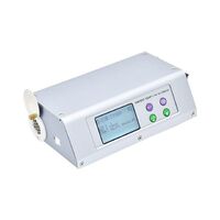
| -T17N(Windows Mobile) |
| - S50 (Android) |
| Field software |
| -Field Genius (Windows) |
| -SurvX (Android) |
| -Engineering Star 5.0 (Android) |
| 1-2 year warranty extension |

Our warranty policy:
1. For GNSS products we offer one year and half a year warranty. For optical instruments(total station, theodolite, Level), we offer 1 years warranty. For accessories we offer 6 months warranty.
2.Product in warranty please send us photos to show the problem . And then we will decide to send you parts or you send the instrument back to us to repair.We are responsible for the double-run freight and other cost.Please make sure to contact us first instead of sending the damaged parts directly to us.
3.For problem out of the warranty period or warranty liability,we will judge the problem and quoted for you.You need to pay double-run freight and the maintenance cost.
4.For all instrument we provide life-long technical support.
Remark:Improper use of the instrument and man-made damage of the instrument is not covered in warranty liability.Warranty only aimed at the problem caused by the product quality.
Our Technical Support:
Before any shipment we will have quality check person to give the instrument a careful quality check (software installation and test for GNSS product).
For all GNSS and optical instrument, you will get the user manual and operating video.
For green hand users we offer free online training (especially for GNSS products), regarding receiver configuration, survey software on controller and post process software operation. If customer needed we also offer charged on site training.
For all of the products we offer lifelong and 24 hours technical support.
Special services:
If you have a survey project, and you are finding a most cost-effective and efficient way to handle it. Just tell us your project specification, we will feedback with professional suggestions as reference.
We offer GNSS raw data process and CAD drawing for survey field end users.
If you have some broken instrument, and want to re-pick up into normal use, send it to use we offer professional repair service for all kinds of survey equipment.

Q1.What kind payment method we accept?
A1.T/T, Western Union, Trade Assurance on Alibaba, Moneygram .
service, you payment will be guaranteed. Because we are not able to receive payment until you confirm goods receipt.
our website. Please contact us freely. We will reply you in time.
Celia Wang
Mobile/Whatsapp/Wechat: 86 13381967278
Tel: 86 13381967278 Fax: 86 021 67892609
Website: www.nctnav.com
http://www.nctrade.en.alibaba.com
Address: Floor 14, Bldg. 1, No. 339, Jiuxin Road, Jiuting Town, Songjiang District, Shanghai, China
Other Products
-
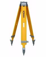 J-1A brand sokkia theodolite total station tripod$20.00 / piece
 -
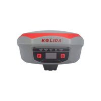 2021 Hot Sale China GNSS RTK Base and Rover Kolida K1 Pro GPS RTK Land Survey Equipment with Tilt Survey$8900.00 - $9150.00 / set