
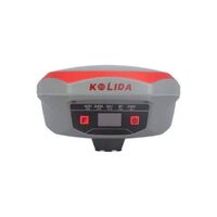
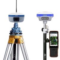
Professional high-precision geodetic survey equipment GPS survey instrument 2023 new cheap rtk GALAXY G3 gnss
- $1700.00 /unit
- 1 unit
- Chengdu Mingjun Trading Co., Ltd.
- Sichuan, China
- Mr cao
PRODUCT DETAIL
| brand: | South | model: | GALAX G3 |
| Supply capacity: | 50,000 pieces per month | Warranty: | 1 year |
| Packaging details: | Packaging details for Less Than Container Load (LCL) service to the United States and get a shipping quote. Hot selling aluminum tripod total station tripod one box packaging port Shanghai/Shenzhen | Place of origin: | Guangdong, China |
| payment terms: | L/C, D/A, D/A, wire transfer | port: | Shanghai/Shenzhen |
| Customization support: | OEM, ODM, OBM |
Specification
Global Navigation Satellite System Characteristics | channel | 1598 |
Global Positioning System | L1, L1C, L2C, L2P, L5 | |
GLONASS | L1C/A, L1P, L2C/A, L2P, L3* | |
Beidou satellite navigation system | Beidou-2: B1I, B2I, B3I Beidou-3: B1I, B3I, B1C, B2a, B2b* | |
Galileo | E1, E5A, E5B, E6C, AltBOC* | |
SBAS(WAAS/MSAS/EGNOS/GAGAN) | L1* | |
Iran Nuclear Safety Authority | L5* | |
QZSS | L1, L2C, L5* | |
MSS L-Band | Beidou PPP | |
Positioning output rate | 1Hz~20Hz | |
initialization time | <10 seconds | |
Initialization reliability | > 99.99% | |
positioning accuracy | Code differential GNSS positioning | Horizontal: 0.25 m + 1 ppm RMS Vertical: 0.50 m + 1 ppm RMS |
Static (long-term observation) | Horizontal: 2.5 mm + 1 ppm RMS Vertical: 3 mm + 0.4 ppm RMS | |
stationary | Horizontal: 2.5 mm + 0.5 ppm RMS Vertical: 3.5 mm + 0.5 ppm RMS | |
fast static | Horizontal: 2.5 mm + 0.5 ppm RMS Vertical: 5 mm + 0.5 ppm RMS | |
PPK | Horizontal: 3 mm + 1 ppm RMS Vertical: 5 mm + 1 ppm RMS | |
RTK (Ultra High Frequency) | Horizontal: 8 mm + 1 ppm RMS Vertical: 15 mm + 1 ppm RMS | |
RTK(NTRIP) | Horizontal: 8 mm + 0.5 ppm RMS Vertical: 15 mm + 0.5 ppm RMS | |
RTK initialization time | 2~8 seconds | |
SBAS positioning | Typically < 5m 3DRMS | |
Banda-L | Level: 5-10cm (5-30 minutes) Vertical: 10-30cm (5-30 minutes) | |
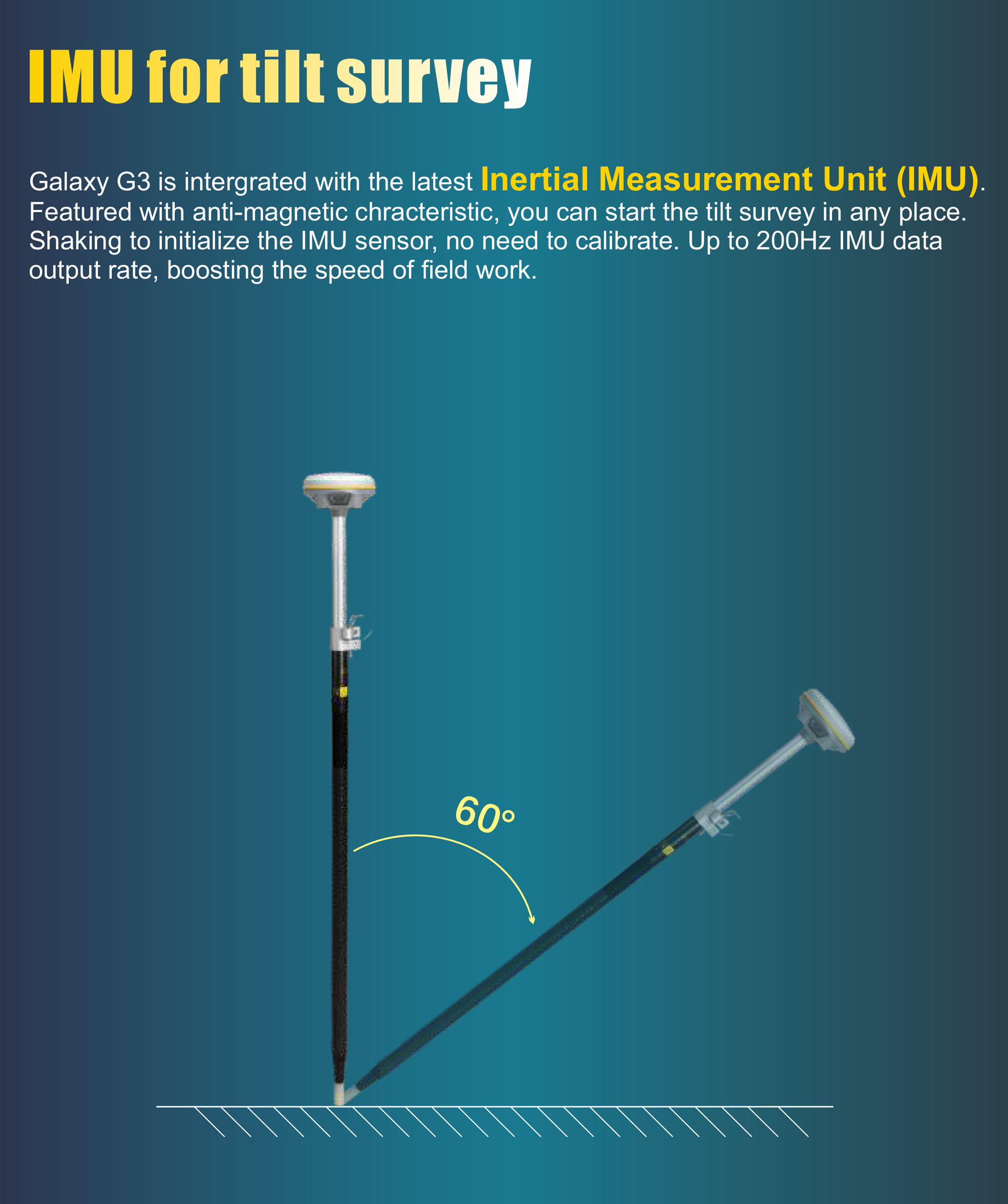
inertial measurement unit | Less than 10 mm + 0.7 mm/° Tilt to 30° | |
IMU tilt angle | 0°~60° | |
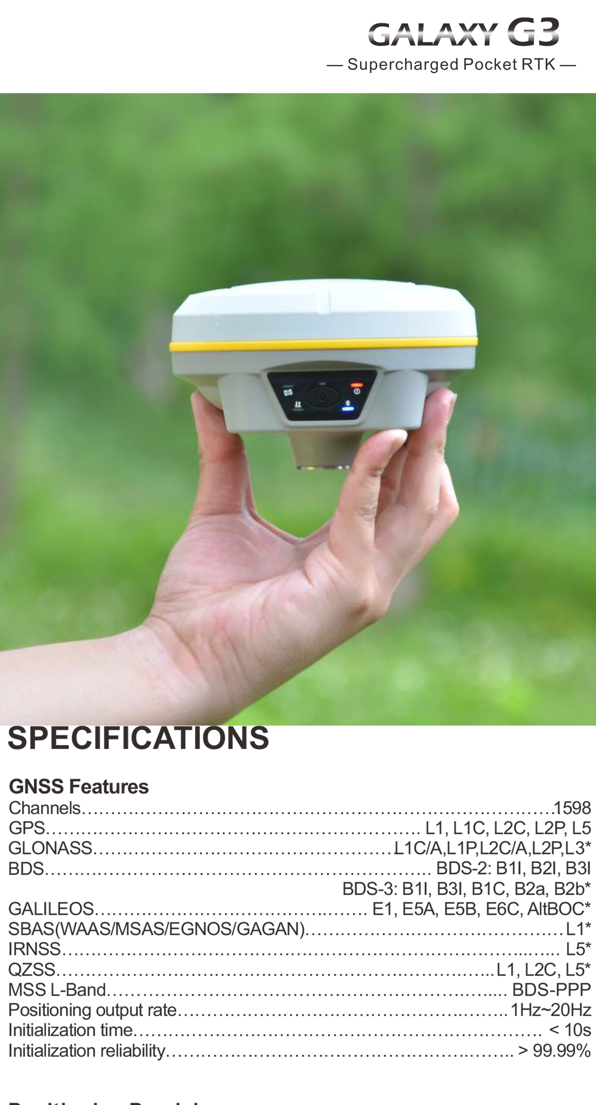
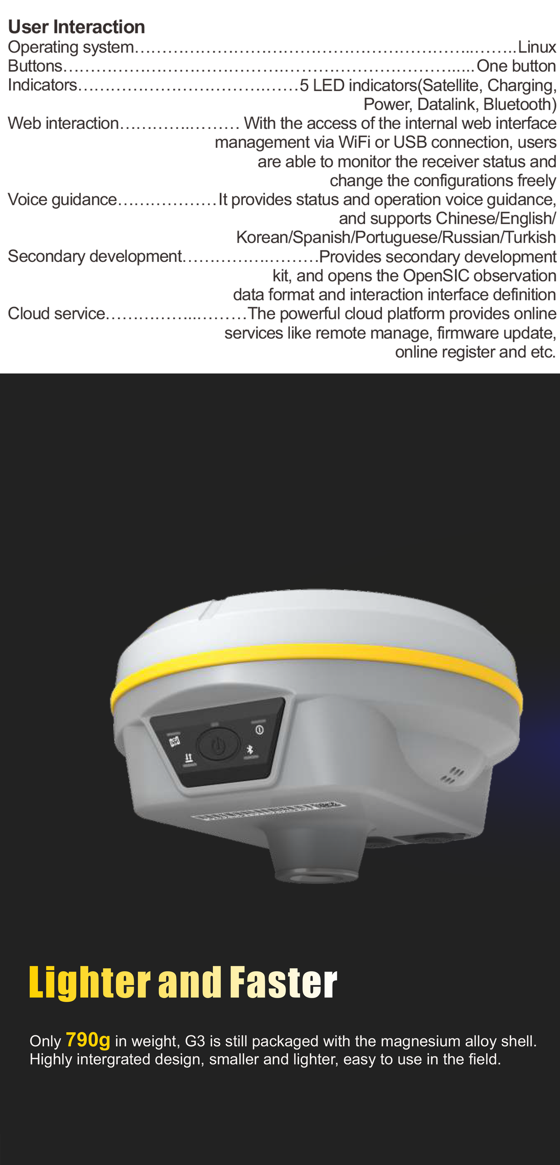
Hardware performance | aspect | 130 mm (width) × 130 mm (length) × 80 mm (height) |
weight | 790g (including battery) | |
Material | Magnesium aluminum alloy shell | |
Operating temperature | -45℃~+75℃ | |
Storage temperature | -55℃~+85℃ | |
humidity | 100% condensation-free | |
Waterproof and dustproof | IP68 standard, can be immersed for a long time to a depth of 1m IP68 standard, comprehensive protection flying dust | |
shock/vibration | Can withstand a 2-meter pole falling naturally onto the cement floor Military standard 810G | |
power supply | 6-28V DC, overvoltage protection | |
Battery | Built-in 7.2V 6800mAh rechargeable lithium-ion battery | |
Battery Life | 15 hours (rover Bluetooth mode) | |
communication | input/output port | 5-PIN LEMO external power port + RS232 Type-C (charging, OTG to USB disk, data transfer with PC or mobile phone, Ethernet) 1 UHF antenna TNC interface |
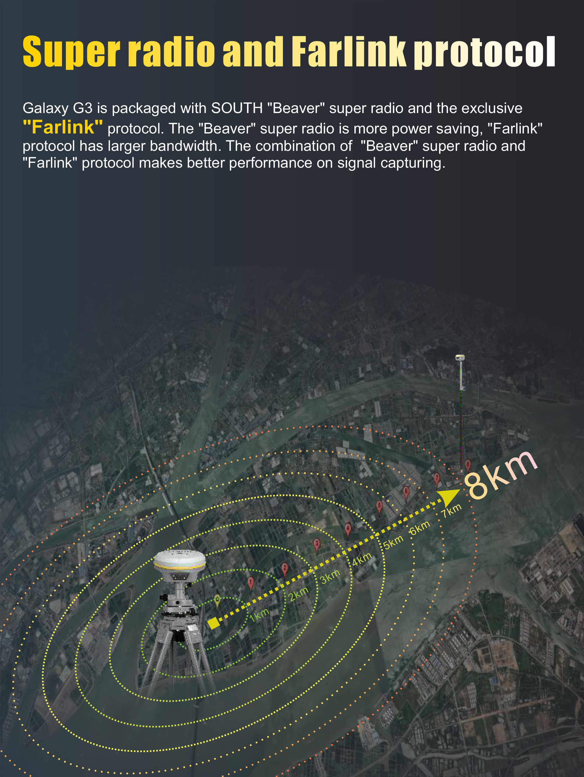
Internal UHF | 2W radios, receiving and transmitting, radio routers and radio repeaters | |
Frequency Range | 410-470MHz | |
Protocol | Farlink, Trimtalk450s, Southern, Huace, China Haida, Satellite | |
Communication range | Typically 8 km using Farlink protocol | |
NFC communication | Realize automatic pairing of receiver and controller at close range (less than 10cm) (controller requires NFC wireless Communication module (other) | |
Bluetooth | Bluetooth 3.0/4.1 standard, Bluetooth 2.1+EDR | |
Wifi | modem | 802.11 b/g standard |
wireless hotspot | AP mode, the receiver broadcasts its hotspots in the form of a Web UI accessible from any mobile terminal | |
WIFI data link | Client mode, the receiver can send and receive correction data streams over the WiFi data link | |
Data storage/transmission | storage | 4GB SSD automatic cycle storage (automatically deletes the oldest data files when there is insufficient memory) Supports external USB storage |
data transmission | USB data transfer plug and play mode Support FTP/HTTP data download | |
Data Format | Static data format: STH, Rinex2.01, Rinex3.02, etc. Differential formats: RTCM 2.3, RTCM 3.0, RTCM 3.1, RTCM 3.2 GPS output data format: NMEA 0183, PJK plane coordinates, SOUTH binary code Network mode support: VRS, FKP, MAC, fully supports NTRIP protocol | |
sensor | electronic bubble | The controller software can display electronic bubbles to check the carbon rod leveling status in real time |
inertial measurement unit | Built-in IMU module, no need for calibration, anti-magnetic interference | |
thermometer | Built-in temperature sensor, using intelligent temperature control technology, monitors and adjusts the receiver temperature | |
user interaction | operating system | Linux |
buttons | One click | |
index | 5 LED indicators (Satellite, Charging, Power, Data Link, Bluetooth) | |
Web page interaction | Access to internal web interface management via WiFi or USB connection allows user to monitor receiver status and freely change the configuration | |
Voice guidance | Provide status and operation voice guidance, support Chinese/English/Korean/Spanish/Portuguese/Russian/Turkish | |
Secondary development | Provide secondary development kit, open OpenSIC observation data format and interactive interface definition | |
cloud service | The powerful cloud platform provides online services such as remote management, firmware updates, and online registration. |
Product Description


VIEW MORE
YOU MAY LIKE


Other Products
-
 CHCNAV i73+ IMU ibase RTK high precision GPS GNSSGPS RTK surveying and mapping equipment GNSS$3200.00 - $3400.00 / set